-
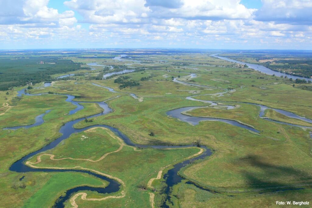
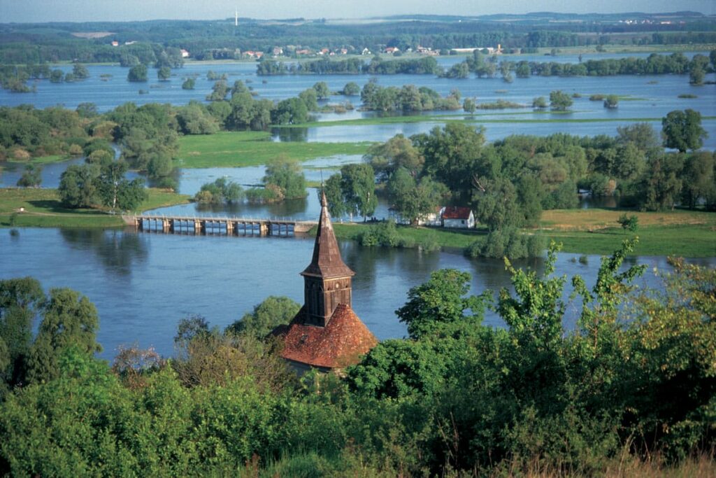
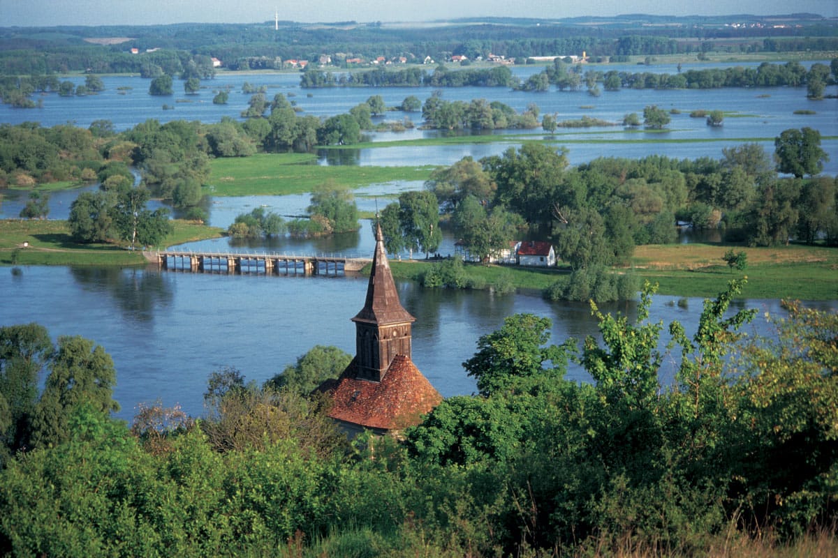
- Polder from the air

To keep the major shipping route Berlin — Stettin (Szczecin) navigable for larger cargo ships all year round, to improve the yield of agriculture in the Oder Valley itself and the drainage for the Oderbruch further south, was the beginning of the 20th century that was largely unobstructed by humans Odertal redesigned according to Dutch plans. Several wet and dry polders were created.
The Dry polder, for example the Friedrichsthaler Polder (5/6) (650 hectares) or the Lunow Stolper Polder (1,680 hectares) are so-called dry polders, which means that they are protected from flooding by dikes all year round and can also be used for agriculture all year round. The so-called Wet or flood polders, for example the Criewener polder (A) (1,644 ha), the Schwedt polder (B) (1,303 ha) or the Fiddichower Polder (10) (1,773 ha) are only protected from flooding in the summer half of the year by so-called summer dykes; in the winter half of the year, from October, the inlet structures are opened, and the then frequently rising Oder water can enter the polders and through outlet structures when the water level is low, they also flow north again. (B) (1,303 ha) or the Fiddichower Polder (10) (1,773 ha) are only protected from flooding in the summer half of the year by so-called summer dykes; in the winter half of the year, from October, the inlet structures are opened, and the then frequently rising Oder water can enter the polders and through outlet structures when the water level is low, they also flow north again. From April 15 of each year, on the instructions of the responsible national park administration, the inlet structures and, after the water has drained according to the natural gradient, also the outlet structures are closed and the water still remaining in the polder is pumped out, which is expensive and energy-intensive after the structures have been closed. As of 2015, the head of the national park administration, after many years of urging the national park association, which is practically the sole owner of the agricultural land in the Fiddichow Polder (10), will at least stop pumping there. A first success.
According to a water management feasibility study commissioned by the State of Brandenburg itself, the association also demands that the inlet and outlet structures in the Fiddichower Polder (10) also remain open all year round so that the water level there can adapt to that of the Oder in at least a semi-natural way . In the Criewener and Schwedter Nasspolder (A/B), too, the inlet and outlet structures must remain open at least until May 31 of each year, longer if possible, of course, to enable natural water conditions.
The National Park Association is also very committed to ensuring that on the Polish side the Gartzer Polder and the Schillersdorfer Polder as the heart of the cross-border International Park Unteres Oder Valley remain unused and continuously connected to the water level of the East and West Oder through year-round open gates. The Polish side of the planned restart of the technical structures, the associated possibility of regulating the water level and the agricultural use of the area to be expected as a result are rejected by the National Park Association and its nature conservation partners on the Polish side.
Historical water management
Until the beginning of this century, the Oder in the lower Oder valley was able to meander largely unhindered. As is so often the case, the Oder also showed the need to continue this up to the mouth after hydraulic engineering interventions in a stream. The drainage of the Oderbruch in the 18th century made hydraulic engineering measures necessary in the lower Oder valley in order to be able to use the lower Oder, which has very little gradient, as a receiving water and to shift the backwater further and further north to protect the Oderbruch. Because of the low gradient, the water in the lower Oder valley can accumulate in strong north winds. Onshore winds raise the level of the Baltic Sea near Swinoujscie and cause the lagoon and Dammschen Lake to be filled in by back currents. Offshore winds have the opposite effect.
-
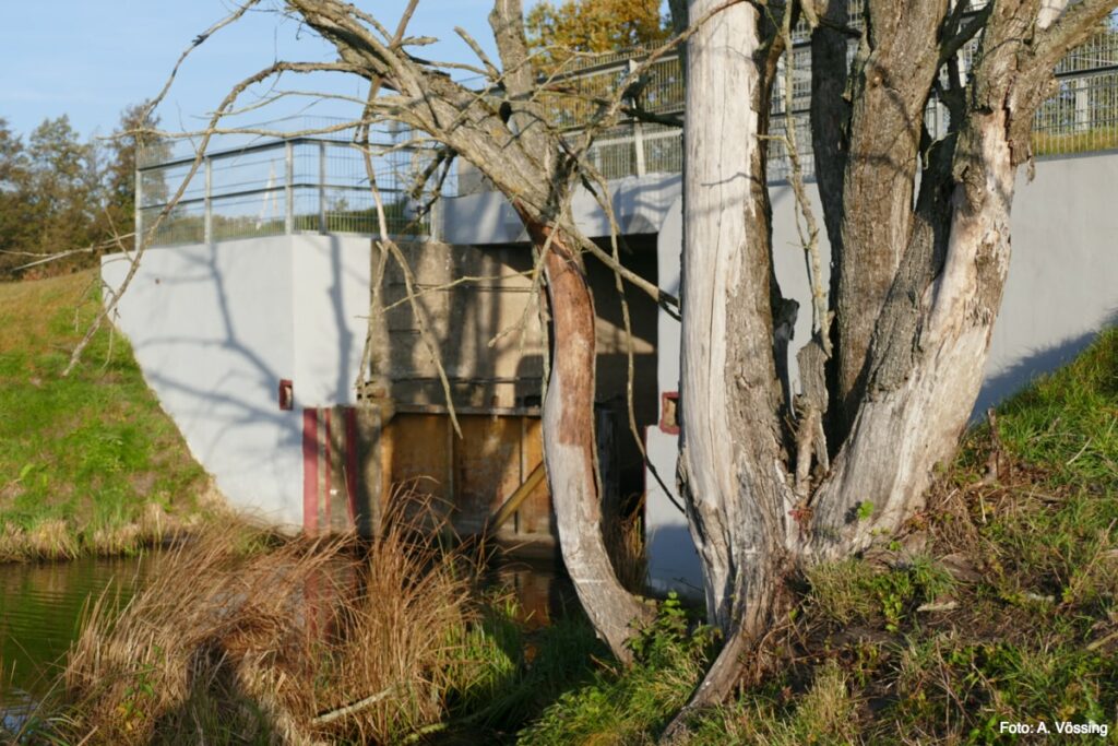
- Hydraulic engineering installation at the Fiddichower Polder (10)

Originally, the Oder was divided into two main arms north of Oderberg, of which the larger, known as the Oder, ran on the western edge of the valley via Lunow, Stolpe and Criewen to Schwedt, while the second main arm, the Meglitze, on the eastern edge of the heights via Hohenwutzen, Zehden (Cedynia) , Bellinchen (Bielinek) and Peetzig (Piasek) to Lower Saaten (Zatoñ Dolny). Below Schwedt and von Niedersaaten, the two main arms changed and branched out. To the north of Gartz and Greifenhagen (Gryfino), two main arms could be seen again, from which the Oder on the western edge led via Gartz and Stettin (Szczecin) into the Papenwasser, the Reglitz on the eastern edge flowed into the Dammschen lake. Both main arms were connected to one another by numerous intermediate arms.
Aim of the hydraulic engineering measures from 19th to the 20th century was now the manufacture and maintenance of a deep, high-performance power hose up to the natural receiving basin, the Dammschen lake. 19th to The 20th century was now the manufacture and maintenance of a deep, high-performance power hose up to the natural receiving basin, the Dammschen lake. The aim was to deepen, shorten, straighten the shipping route and make it navigable at all times. In addition, sand deposits were to be prevented, the discharge of the flood was to be accelerated and the receiving water for the Oderbruch improved. Last but not least, at the express request of the meadow owners, who did not want to do without the abundant fertilization with winter floods, the area should be able to be flooded without restriction by winter floods.
-
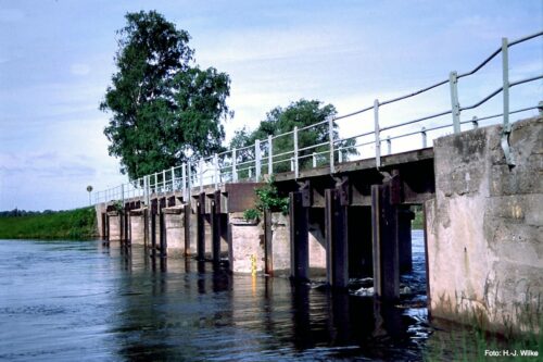
- open dyke gate

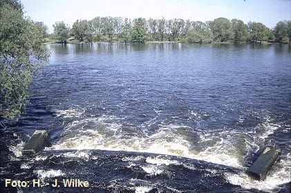
The Hohensaaten-Friedrichsthaler waterway was created, which used the old Oder bed south of Schwedt, while north of Schwedt, was created for the realization of the large shipping route Berlin — Stettin, i.e. for continuous use by ships with a load capacity of 600 t, and as a receiving water of the Oderbruch Canal puncture was required. The Ostoder, i.e. the former Meglitze and today’s Stromoder, was supposed to be the main river to carry the amounts of water and suspended matter coming from the Oder course into the Dammschen See by the fastest possible route. The summer dykes west of the Ostoder were to serve to hold the water from the upper reaches together in a closed cross-section up to a water flow of 1,600 m³/sec. The polder area should only be flooded when the water level is greater. As soon as the water level on the Ostoder fell, the polder area should quickly dry out to the lower Hohensaaten-Friedrichsthaler waterway and to the Westoder. In order to ensure a year-round navigable large shipping route and a secure flooding of the Oderbruch, regardless of the changing water level of the Oder, the Hohensaaten-Friedrichsthal waterway was decoupled from the Ostoder, which was expanded to the main stream, by a weir at Hohensaaten and a lock on the Schwedt crossing. It is only open to the north to the Westoder, but it was also separated from the river Ostoder by the Marienhofer weir near Fiddichow (Widuchowa). However, up to 650 m³/sec. can be discharged into the Westoder via this weir as soon as the Ostoder has reached a total discharge of 1,600 m³/sec. At the Hohensaaten weir, up to 20 m³/sec. can be discharged from the Stromoder into the Hohensaaten-Friedrichsthal waterway to regulate the water level.
Between the Hohensaaten-Friedrichsthaler Wasserstraße and the Stromoder in the south and the east and west or in the north, a polder system planned by the Dutch was set up. While the southern dry polder at Lunow and Stolpe is protected from flooding all year round by dikes, the wet polder to the north in the eastern summer dike, in the western winter dike and in the dikes to the Schwedter Querfahrt has numerous inlet and outlet structures that are developed as sluices and sluices . On the German side, the wet polders (5,400 ha) are flooded in winter via inlet structures in the summer dike from the north, starting between November 15 and December 15 each year. In the period from March 15 to April 15, the Deichtore will be closed again, the water flows according to the gradient into the Hohensaaten-Friedrichsthaler Wasserstraße, the Schwedter Querfahrt and the Westoder, or it is pumped out with the help of the pumping stations around the To be able to use polders for agriculture at an early stage. Summer floods, which also lead to flooding, occur only rarely, usually once a decade. The summer dike west of the Stromoder is designed as an overflow stretch over a length of 800 m below Crieort. It is flooded during high water if the capacity of the inlet structures is insufficient.
-
- Water management
The extensive floodplains in the lower Oder valley have not only proven themselves as area filters, but also as effective flood protection, not least during the flood of the century in the summer of 1997. In July there were two heavy rains in Moravia and Upper Silesia within 10 days. The first time there was 8–10 billion m³ of rain, the second time 4–5 billion m³ of rain came down. As a result, the Oder had to transport six times the amount of water instead of the usual 400 m³/sec. The water level at Hohensaaten reached a high of 7.29 m on July 31. In contrast to the upper reaches of the Oder in Moravia and Silesia, where there are largely no floodplains, there was no significant damage in the lower Oder valley. The high water peak was absorbed by the extensive floodplain landscape of the lower Oder valley, the Oderbruch and downstream Stettin (Szczecin) protected from flooding.
In the final report of the Brandenburg state government of March 31, 1998, the flood damage was estimated at 648 million DM. According to the Federal Institute for Hydrology in Koblenz, such so-called floods of the century could repeat themselves more frequently in the future. In the context of global warming, the global temperature will rise by around two degrees by 2030, which means that the amount of rain in Germany will increase by 100 l / m² per year. The hydraulic engineering systems and the polder system require a high level of personnel and financial expenditure for their maintenance. The responsible Brandenburg Ministry of the Environment assumes at least 800,000 DM annual maintenance and operating costs.
The polder system was created at a time when every square meter of arable land was needed for agriculture. Only a small part of the hydraulic engineering systems is required to secure the international waterway between Berlin and Szczecin and for flood protection, which can already be seen from the fact that the complicated polder management in the Gartzer and Schillersdorfer polder has been discontinued since 1945. For example, the winter dike east of the Hohensaaten-Friedrichsthaler waterway remains indispensable. Most of the other facilities, starting with the summer dyke that accompanies the stream or to the west, to the inlet and outlet structures, which require a lot of maintenance and care, the pumping stations and the weeding of the ditches, are basically additional subsidy measures for local agriculture.
On the German side, the hydraulic engineering systems were operational during the GDR era, but had not been fundamentally repaired and renewed for a long time. After a discussion, at least in environmental circles, as to whether it even made sense to renew the inlet and outlet structures after the establishment of an alluvial meadow national park, gradually all the inlet and outlet structures were completely new and since money does not play a role in Germany built in a modern way, even if they may no longer be used in the future. After all, this can be used to protect the polders from flooding in the event of unexpected spring or summer floods. But actually this million dollar investment has been spent quite pointlessly.
After the summer flood of 1997 at the latest, it was decided to raise and widen all winter and summer dykes, although they were not endangered during this spectacular flood event in the national park area. For the winter dike east of the Hohensaaten-Friedrichsthaler Wasserstraße, this may make sense for the population west of the Hohensaaten-Friedrichsthaler Wasserstraße for flood protection reasons, but it is rather pointless when it comes to upgrading and maintaining the summer dyke. They are even more of a hindrance for a real floodplain national park. If the inlet and outlet structures remain open all year round, their effect, which disrupts the natural floodplain process, is somewhat reduced.
As a result, all hydraulic engineering systems in the lower Oder valley have been brought up to date in the last 25 years since reunification.
On the Polish side, polder management ceased after the end of the war. Even without the polder areas, Poland had sufficient arable land. Most of the summer dikes in the Zwischenoderland are still intact, but the inlet and outlet structures and the locks are no longer functional. They are open to natural flooding all year round.
The responsibilities in the area of water management in the lower Oder valley are complicated. In addition to the Federal Waterways and Shipping Office in Eberswalde, the State Environment Office, Department of Water Protection and Water Management, the Lower Water Authority of the two affected districts of Uckermark and Barnim and the “Welse” water and soil association are responsible.
Near-natural water management
-
- Flooding in the Lower Oder Valley National Park
There is no question that the future of the Lower Oder Valley Auenational Park depends on the quality and the amount of water used in the Oder, which varies according to the season. Right from the start, the National Park Association saw its task as promoting the most natural water conditions possible in the lower Oder valley. Thanks to his many years of urging, the national park administration stopped pumping out the water, which was cost-intensive and energy-intensive, in 2015, at least 20 years after the establishment of the National Park, at least in the Fiddichower Polder (10) — a first success! After all, this requirement was already in the maintenance and development plan adopted in 1999 and was expressly qualified as feasible and sensible by a water management feasibility study commissioned and financed by the state of Brandenburg. The National Park Association had backed up its demand with an intensive land acquisition strategy, which enabled it to oblige all users to the contractually guaranteed willingness to accept natural water conditions without recourse claims. At the latest with the provisional assignment of ownership in the name of the company land restructuring in the summer of 2013, which plans practically the entire Fiddichower Polder (10) as a wilderness area (Zone I) and assigns it to the National Park Association, there was really no longer any reason to continue pumping the water out of the floodplain national park.
Water quality
The construction of new wastewater treatment plants in the Oder catchment area and the closure of some environmentally polluting industries in the Oder catchment area have led to a decrease in pollution in the Oder water and the polders flooded by the Oder water, in particular with heavy metals. Nevertheless, the pollution of the soils in the floodplain as in the wet polders is still very high. According to the current studies, the water in the Oder, in the Hohensaaten-Friedrichsthaler Wasserstraße and in the polder waters is of medium quality.
Expansion of the oder river
Apart from two smaller weirs in Silesia, the Oder is one of the last large rivers in Central Europe that have not yet been built across. This is also due to the fact that behind the Moravian gate, as a lowland river, it only has a slight gradient. Since the Oder, unlike the Rhine, is not fed by glaciers, the navigability of the Oder remains dependent on the rainfall in the Oder catchment area, especially in the Giant Mountains. This means that the Oder is not navigable on a few days because of high water and on many days because of low water. That is why the Polish side in particular has repeatedly expressed interest in expanding the Oder, combined with the hope of EU funding, currently again by the national-conservative government in Warsaw. The German side, on the other hand, is clearly more reserved. After lengthy negotiations, on April 27, 2015, the bilateral “Agreement on the joint improvement of the situation on the waterways in the German-Polish border area” was signed. The aim of this agreement is to optimize future flood discharge conditions on the border or, to ensure stable fairway conditions, especially for the use of the German-Polish icebreaker fleet, and to enable coasters to travel between the port of Schwedt and the Baltic Sea.
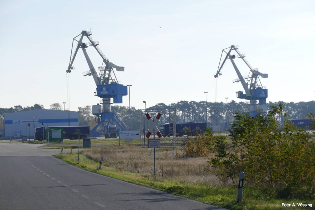
Schwedt high-sea port
The new Schwedt harbor is already accessible for smaller coasters today, but at the latest after the deepening of the Klützer crossing. The paper mills in Schwedt had asserted a certain need. However, in earlier planning, care was always taken to ensure that coasters could only sail as far as the Schwedt harbor and not, for example, to the paper mills’ own bulwarks located a few meters to the south. But it is precisely this direct connection that would be important to the paper mills in order to avoid costly, additional reloading with all the dangers of damage. Above all, the city of Schwedt attaches great importance to bringing the still highly deficit port close to profitability. The new, completely oversized Schwedt port was built from the ground with very high subsidies on the edge of the national park, but is still in deficit due to a lack of tonnage and is cross-subsidized by the Schwedter Stadtwerke from economically more profitable areas. Most of the port’s income does not come from handling, but from the industrial companies located in the port area. At the beginning of the port planning, the National Park Association publicly pointed out that this uneconomical investment would require subsidies for decades to come. That’s how it turned out.